This website uses cookies so that we can provide you with the best user experience possible. Cookie information is stored in your browser and performs functions such as recognising you when you return to our website and helping our team to understand which sections of the website you find most interesting and useful.
Bluetooth Indoor Positioning Systems: Implementation Features & Alternatives

Andrey Solovev
Chief Technology Officer, PhD in Physics and Mathematics

Anna Petrova
Writer With Expertise in Covering Electronics Design Topics
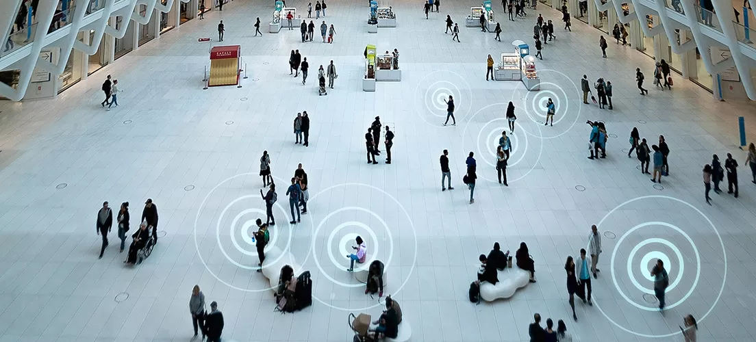
Many people worldwide regularly use positioning systems. The most popular of them are location services relying on geographic data and satellite navigation (GIS and GNSS). However, these systems only work efficiently outdoors and don’t work so well in enclosed areas. Indoor positioning systems are special solutions that use technologies and methods other than satellite data. Bluetooth is one of these technologies. In this article, we’ll give you a basic idea about indoor positioning systems and describe how Bluetooth positioning services work, what methods they use, and how you can implement them in your project.
What Is an Indoor Positioning System and What Is It Used for?
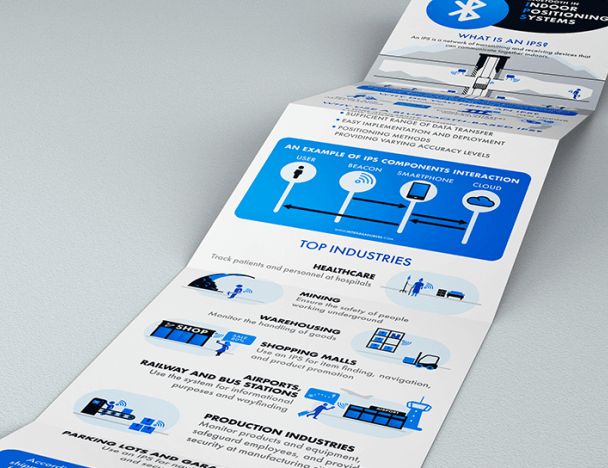
An indoor positioning system or IPS is a network of transmitting and receiving devices (separate or two-in-one) that can communicate together indoors.
As the name suggests, the major purpose of an IPS is to detect the position of an object that can be both animate and inanimate. Once it is detected, the system can keep track of the object’s location and identify it from the set of like objects.
Having this information at hand can improve work processes and help with solving problems in many fields. Here are some IPS applications and purposes the system may serve:
- Production industries (monitor products and equipment, safeguard employees, and provide security at manufacturing sites);
- Healthcare (track patients and personnel at hospitals);
- Mining (ensure the safety of people working underground);
- Shopping malls (use an IPS for item finding, navigation, and product promotion);
- Airports, railway and bus stations (use the system for informational purposes and wayfinding);
- Warehousing (monitor the handling of goods);
- Parking lots and garages (use an IPS for navigational and security purposes).
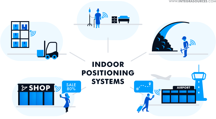
To sum up, you can use indoor positioning in any business area and for a variety of purposes as far as your fantasy and budget permit. For example, wayfinding is an important feature suitable for lots of places, such as museums, exhibitions and trade shows, sports facilities, parks, and tourist attractions. An IPS is an essential part of most smart networks, including the Internet of Things applications.
Technologies Used for Indoor Positioning Systems
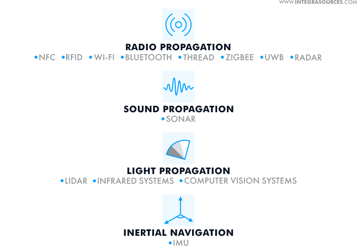
Satellite radio signals work well on the surface but cannot reach receivers inside buildings or underground facilities. Therefore, GPS and Galileo cannot be used in indoor positioning systems. For this purpose, businesses and organizations utilize alternative technologies based on different types of signals that can be classified as follows:
- IPS using radio signals
Such systems detect object locations with the help of radio signals propagating from transmitters to receivers. They include NFC, RFID, Wi-Fi (WPS), Bluetooth, Thread, ZigBee, ultra-wideband (UWB), Radio Detection and Ranging (RADAR).
- IPS using sound signals
These systems use echolocation. They calculate the distance to an object based on the time an emitted ultrasonic signal travels to it and back to the receiver. One particular example of this technology is SONAR (Sound Navigation and Ranging) used to position objects under water.
- IPS using light signals
This IPS type comprises light-emitting and light-reflecting objects and includes Light Detection and Ranging (LiDAR), infrared systems, and computer vision systems.
- IPS using inertial navigation
These systems include inertial measurement units (IMUs) that use a set of sensors such as an accelerometer, a gyroscope and, sometimes, a magnetometer to track the motion of an object in three-dimensional space.
To implement an indoor positioning technology, you might need different hardware and software solutions as well as positioning methods. Thus, you can use a tag to track a moving object and a beacon if the object is stationary. Tags are normally smaller and lighter than beacons; however, both of them have various configurations that differ in price and complexity. You can program the devices according to your needs, for example, to provide two-way communication.
Smartphones, tablets, and other portable devices can serve as receivers. They convert signals received from tags or beacons into position information, i.e. coordinates. As for software, developers may need to design an SDK, library, mobile application, communication protocol, etc. The positioning methods one can use include the following:
- Angle of arrival (AoA)/Angle of departure (AoD)
These methods rely on measuring the angle at which the signal sent by the transmitter reaches the receiving device. They require multiple sensors and consequently additional costs for the hardware; and because of that, they provide better accuracy. AoA and AoD are commonly implemented in positioning systems using Bluetooth.
- Received signal strength indication (RSSI)
RSSI allows for estimating the location of the object by the intensity of the signal it emits. This method can show poor results because the stationary and moving objects surrounding the transmitter can affect the signal negatively. RSSI is popular among such wireless networks as Wi-Fi, Bluetooth, ZigBee, and Thread.
- Trilateration (multilateration)
This method works when the network comprises three or more transmitting devices. Once you know the distances between some reference objects, you can measure the distance to the target object. Trilateration involves mathematical models and is often used to increase positioning accuracy in ultrasound, Wi-FI, UWB, and Bluetooth positioning systems.
- Triangulation
This is another method based on mathematical calculations. As its name implies, triangulation involves measuring the distance to the object by building triangles between the reference points around it. Bluetooth, Wi-Fi, and UWB systems use triangulation as an additional positioning method.
- Dead reckoning
This is an indoor location tracking method mostly used by IMUs. To detect the position of the object through dead reckoning, you should know its previous location and speed. This method lacks accuracy because of the position errors accumulating with time.
- Simultaneous Localization and Mapping (SLAM)
SLAM algorithms use data taken from the sensors or camera to build a map of the place where the object is located. IMUs and computer vision systems turn to this method to track the position and movements of the object.
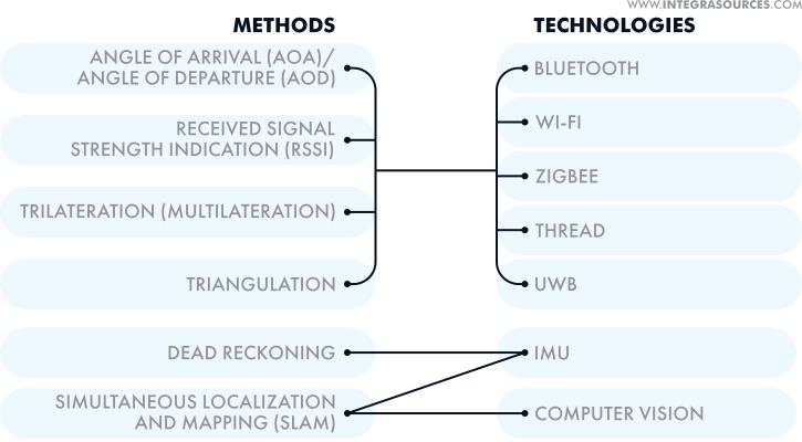
To achieve better accuracy (and if the chosen technology permits), you can combine different positioning methods or implement your own solutions, for example, customize beacon firmware or develop bespoke algorithms.
The differences between indoor positioning technologies lie in their implementation, cost, positioning accuracy, and other performance features. All of them have their own advantages and weak points.
For example, an inertial measurement unit and a computer vision system can ensure high positioning accuracy only when used in combination with other technologies. An ultrasound system can provide accurate object detection unless the surrounding objects distort the ultrasonic waves used. To make this IPS reliable, you can implement the necessary filters and add a sufficient number of transmitting devices.
An infrared system also needs multiple tags installed in the facility. In addition, such a system cannot track an object moving from one room to another because of the limited capabilities of the light signal.
Radio-based technologies are very common because of their availability, simplicity, and ability to track objects in real-time, so you can use them in real-time locating systems (RTLS).
RFID and NFC are two communication technologies often used for tracking and positioning objects by many industries. They are cheap and easy to implement but are only suitable for short ranges. Wi-Fi-based systems cover larger areas but will require much more power. Another problem typical for this solution is an unstable connection. UWB systems demonstrate excellent accuracy and perform well in various environments. However, they are expensive and difficult to implement.
Another popular option is the Bluetooth indoor positioning technology. Just like every other location technology, it has pros and cons. In this copy, we will analyze it, reveal its advantages, and find out how Bluetooth can be implemented in your project.
Reasons to Use Bluetooth in Indoor Positioning
The earlier versions of the Bluetooth indoor location technology allowed for its use as a proximity solution that rested on the RSSI method, supported by trilateration. So there were no high expectations about its positioning accuracy, which could be from 1 up to several meters. Despite the inaccuracy, Bluetooth positioning could still offer some competitive advantages back then.
Thus, Bluetooth Low Energy (BLE) introduced with the Bluetooth 4.0 version in 2010 made the technology a lightweight solution with extremely low power consumption. The BLE-based IPS could comprise multiple devices that had:
- reduced size;
- low production costs;
- extended lifetime.
The largest semiconductor manufacturers, including Texas Instruments, STMicroelectronics, Qualcomm, Nordic Semiconductor, integrated Bluetooth LE into their products, making BLE indoor positioning widely available.

As time passed, the technology acquired new features and upgrades. In 2017, Bluetooth 5 made it possible to create highly-scalable mesh networks that offered non-hierarchical many-to-many communications. A mesh network can be integrated into an indoor positioning system to extend its capabilities and increase location accuracy.
Released in 2019, version 5.1 opened up more opportunities for Bluetooth positioning services. Apart from RSSI, the new direction finding capability allowed the system to use AoA and AoD supported by triangulation and detect an object’s position with much higher accuracy. Thus, in addition to proximity solutions, Bluetooth 5.1 opened the door to the wide use of the technology in IPS and RTLS solutions.
Bluetooth has some apparent advantages over other radio-based solutions. First, Bluetooth indoor positioning is highly energy-efficient and can ensure a long lifespan for a wireless system. Second, its latest versions offer advanced positioning techniques that provide increased accuracy (up to centimeter-level).
Third, Bluetooth is omnipresent. According to the 2023 Bluetooth market update, annual shipments of Bluetooth location services devices have grown from 68 million in 2018 to 209 million in 2022. This number is expected to reach 515 million in 2027.
Most chips today have BLE, and so do most mobile devices including smartphones. This fact makes it considerably easier to implement and deploy the technology.
Another alternative that can compete with Bluetooth in indoor positioning is Wi-Fi-based systems. Such solutions have similar characteristics and enjoy popularity. But Bluetooth provides a slightly longer range due to a lower data rate. On top of that, BLE devices are easier to program compared to Wi-Fi-based solutions. Lastly, Bluetooth-enabled devices consume less power.
To sum up, Bluetooth is a reliable technology that you can use for various location solutions, including:
- wayfinding;
- point of interest (POI) information;
- item finding;
- people and asset tracking.
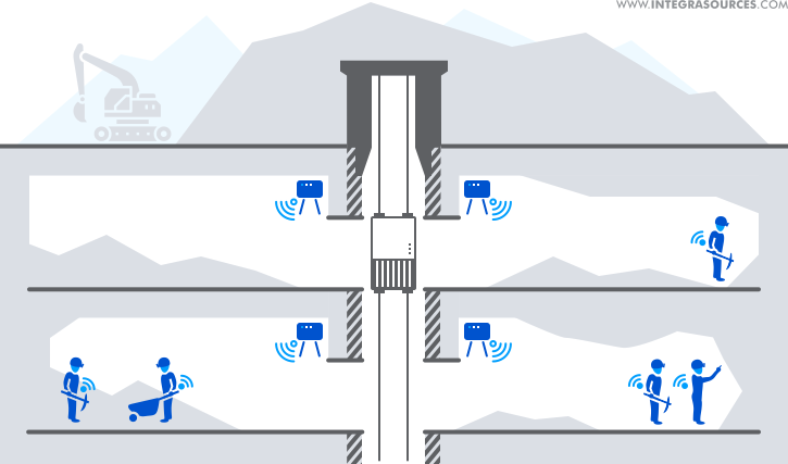
For example, we integrated Bluetooth beacon indoor positioning into our tracking solution to ensure the safety of people working underground. How do Bluetooth beacons work? They broadcast data packets with unique identifiers recognized and differentiated by a receiving device. So, the beacons installed in the mines sent out signals, and the gateway devices read the signals and determined their proximity.
Challenges of Implementing Bluetooth Indoor Positioning
Implementing a Bluetooth Low Energy indoor positioning project will depend on your technical capabilities, specifications, and budget. First of all, it’s necessary to decide whether you should build an IPS from scratch or integrate it into your existing solution. This will determine the choice of positioning methods.
If your Bluetooth version is less than 5.1, you can only use RSSI, coupled with trilateration. This method is suitable for proximity solutions intended for:
- sharing information;
- finding items and points of interest;
- promoting products and services.
In one of our projects, we developed a BLE indoor positioning solution for large shopping malls. Business owners could use it for marketing purposes, informing visitors of promotional offers and discounts. The customer asked us to create an IPS with BLE beacons that could communicate with a mobile application via Bluetooth 4.0. After determining the location of the app users, the system could provide them with the relevant information.
We built a mobile SDK that read signals from the transmitters and sent the beacon data (ID and RSSI) to the cloud. To support the RSSI measurements, we used trilateration to calculate the location of the app user. As a result, the positioning accuracy could reach up to 1 meter.
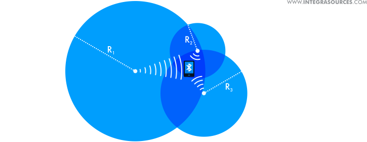
The position calculations can take place either in the app or on the cloud server. The mobile device performs this function if the Internet connection is unavailable or unstable. This can be a hard and energy-consuming task, but in this case, you don’t need to deploy a server and connect to it all the time. If you want to build a lightweight application with low power consumption, you can perform calculations on the server-side.
The positioning accuracy will also depend on the number of beacons you install in the facility. So, to locate the object’s position correctly, make sure the beacon density is high enough. The IPS we developed could support an unlimited number of beacons with a density of at least 3-4 devices per 200m².
For this project, we used Apple’s iBeacon protocol that works well for Bluetooth beacon indoor positioning solutions. iOS devices can natively read the iBeacon format of data packets. Android-based devices will also receive the packets, but to unpack them, you’ll have to integrate additional software components into the app.
Alternatively, you can either use other protocols such as AltBeacon and Google’s Eddystone or develop a custom solution. Sometimes it’s hard to find an off-the-shelf product that could fully meet customer needs. It happened to our partner who implemented indoor location tracking using Bluetooth proximity beacons. By customizing beacons for the asset tracker, we extended the beacon battery life, added new features, and improved the efficiency of the system.
If your system supports the latest Bluetooth Specification version, you can use the direct finding techniques. With the AoA and AoD methods, you can achieve pinpoint accuracy in Bluetooth location services’ deployments, such as wayfinding and real-time locating or tracking.
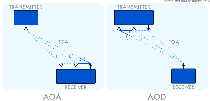
In the AoD method, the receiver with a single antenna reads signals from multiple antennas of the transmitter. Each signal arrives at a certain angle and has a certain time of arrival (ToA). Knowing the distance between the transmitter’s antennas and the time intervals between the signals (time difference of arrival, or TDoA), we can measure the AoD and the distance between the transmitter and the receiver. This information allows the IPS to detect the position of the object.
The AoA method applies a similar principle yet in an inverse manner: the transmitter sends a signal from a single antenna to multiple antennas of the receiving device.
If the network comprises several devices, you can increase the accuracy by using triangulation as a supporting positioning method. To keep the inaccuracies in the position calculations to a minimum, you can crosscheck the data with the help of filtering algorithms, for example, the Kalman filter.
Like any IPS, indoor positioning with Bluetooth is not a perfect solution as it can also have errors and implementation challenges. The biggest challenge you’ll have to face is to detect signals in noisy environments.
It is easier to deploy a local positioning system in a static environment. The conditions stay unchanged to a certain degree, so the position calculations will not require considerable corrections. If a Bluetooth IPS works in a room or facility full of moving objects, it’s much harder to maintain the signal integrity, and thus locate the object correctly. To improve the situation, you can increase the number of beacons per square meter in the facility.
You can always achieve better accuracy by using additional positioning methods. The more methods you use, the more reliable data you can get. However, if you plan to apply the direction finding techniques in your system, make sure all devices in the network support the Bluetooth 5.1 or higher specification. Otherwise, you’ll have to use the methods available under your current version.
Sometimes, implementing an IPS from the ground up makes more financial sense. The advanced solutions streamline the workflow, making your business more efficient.
To ensure the proper work of your BLE-based indoor positioning system, you should create a detailed map of the place where you’re planning to deploy it. We highly recommend you choose a user-friendly software tool to map out the room and convert this information to the processing algorithm of the cloud solution, mobile application, or firmware of the receiving device. The task is no big deal, but it still takes some time and effort.
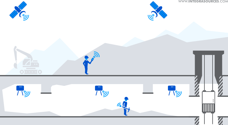
If you need to position and track people or objects both inside and outside the building, you can combine different technologies and switch between the modes. For example, you can use a Bluetooth location tracker indoors and shift to GPS for outdoor positioning. Integra implemented such a solution for a location-aware service for the enterprise. The system could switch automatically between GPS and Bluetooth beacons, providing real-time tracking with high accuracy and low power consumption.
Conclusion
An indoor positioning system is a multipurpose solution that can find its application in many business areas. For example, by using an IPS, hospital personnel can monitor patients, passengers can find a terminal number in an airport, and museum visitors can learn about artifacts.
There are plenty of indoor location technologies that can use different positioning methods. When choosing a technology, you should take into account various factors, including:
- budget;
- functional and technical specifications;
- type of facility;
- environmental conditions;
- technical expertise of the development team.
Bluetooth is a widespread IPS technology that can provide connection stability with minimum power consumption. The latest features enable Bluetooth to locate and track objects with high positioning accuracy and thus expand its application area.
If you want to make sure that a BLE-based IPS is a viable option for your project, feel free to get our professional advice. We have extensive experience in customizing beacons, building SDKs, libraries, mobile apps, cloud platforms, and other solutions necessary to deploy a location service.
Share this article


Related
materials
Bluetooth in Indoor Positioning Systems: Technology overview in Infographics.
Bluetooth is one of the most popular indoor positioning technologies. It is widely used to detect and track objects and...
LEARN MORE
LEARN MORE

Bluetooth Mesh: Technology Overview, Examples, Alternatives, and First-Hand Experience
Hands-on experience from our team, which dug into this quite new technology. We have already implemented several projects based on...
LEARN MORE
LEARN MORE


PaaS Solution for Building Location-Aware Services for Enterprise
The solution is an asset and people tracking system that consists of a network of Bluetooth beacons, a special gateway...
LEARN MORE
LEARN MORE


